
Our Services

Architectural As-Builts
The objective is to ensure that every surface in your area of scope is modeled accurately. After completing a thorough site survey we implement scan to BIM. Additionally a 360 walk through tour is hosted online, complete with button links to drone and site photos for client, contractor, and designer communication.
: columns, beams, roof systems, floor systems, walls, doors, windows, mechanical systems, plumbing fixtures, lighting fixtures, outlets, data panels, base trim, casework, built in shelving, alcoves, exterior lighting, exterior features, topography, landscape, hardscape :

Mechanical and Structural As-Builts
At the hub of every building are its heating, ventilation, air conditioning systems, and mechanical room. We have years of experience documenting central utility plants, boiler and chiller rooms, mechanical and electrical rooms, and fuel rooms. Documentation of these important spaces starts with top tier technology and continues with great communication as we help you develop an asset management plan.

Historic Preservation
When working with historic preservation sites or parts, thorough digital documentation of the context, materials, and dimensions is an absolute must. Our 3D scanning equipment and technical modeling skills have helped document, preserve, and restore or rehabilitate many historic landmark sites and parts. In addition to LiDAR scanning, implementing drone photography can often help gather contextual information. Accurate as-built construction documents are the final key ingredient to gaining approval from building permitting and historic preservation authorities.

sUAS Topographic Survey Mapping
Using drones [or sUAS, UAV] equipped with LiDAR sensors and high resolution cameras, we document land for development, ski resorts, golf courses, construction sites, mines, material volumes, and more. The final product is a CAD file including .tin .dsm or .dtn surface complete with break lines, elevation labels, layers, and labels on your company template. Our pricing is very affordable and we are fast! *We are certified remote pilots under FAA UAS Part 107.
UAV LiDAR / Aerial Laser Scanning Breakdown
Pre-Construction - Aerial photography of existing terrain conditions.
Pre-Construction - Photo and video documentation of existing roads and right-of-way conditions to reduce liability claims after construction.
Post Construction - Transmission Line Sag Verification
Post Construction - Topographical mapping accurate to 2”
Post Construction - Orthomapping with a high resolution photo map deliverable
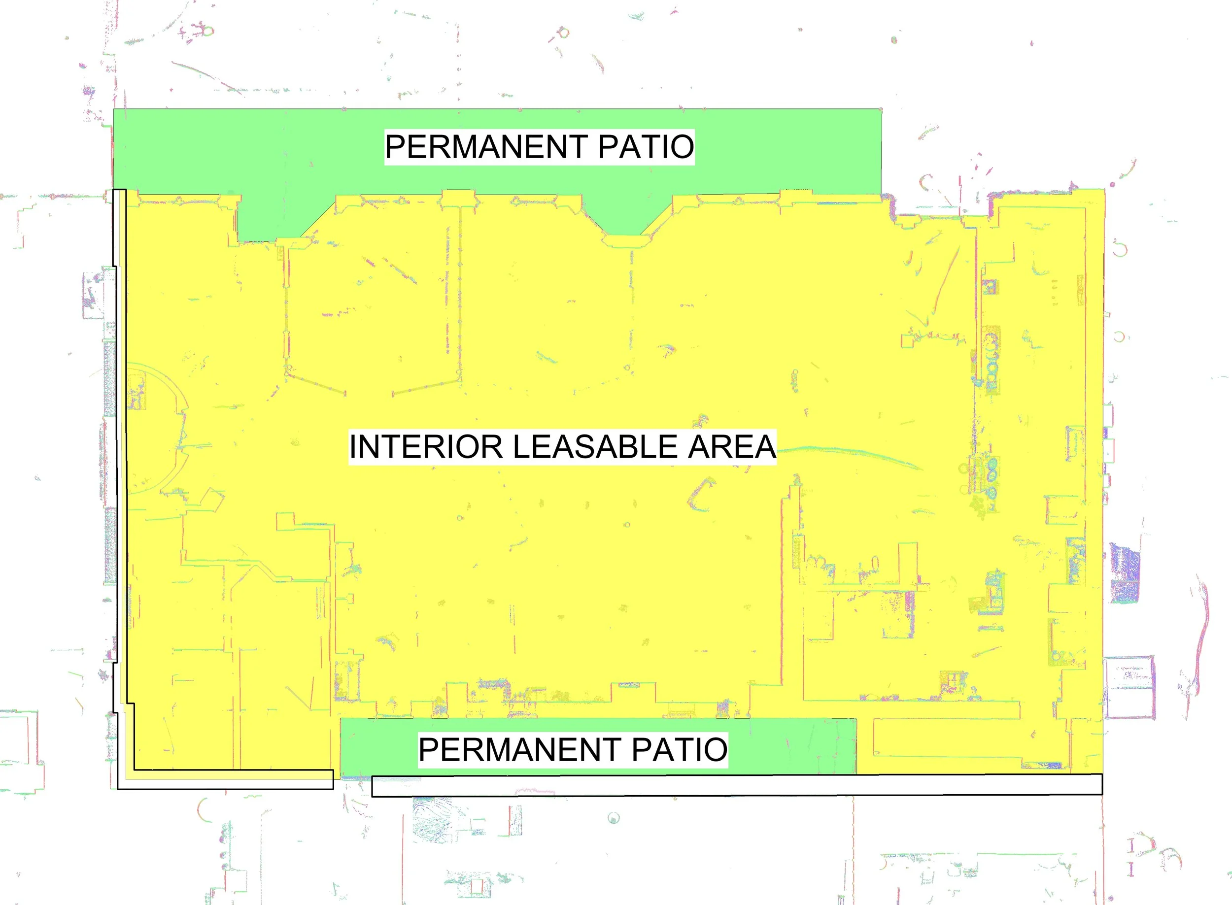
BOMA Gross Leasable Area calculations
The BOMA standards of measurement for each building type are published by the Buildings Owners and Managers Association (BOMA) International and are approved by ANSI (The American National Standards Institute). Following these standards promotes clarity and transparency within the various real estate industries for capturing Gross Leasable Areas for all building types. 3D Data Pro employs survey-grade LiDAR measurements and BIM software for maximum accuracy at every site.
Small-Scale Scanning and Modeling
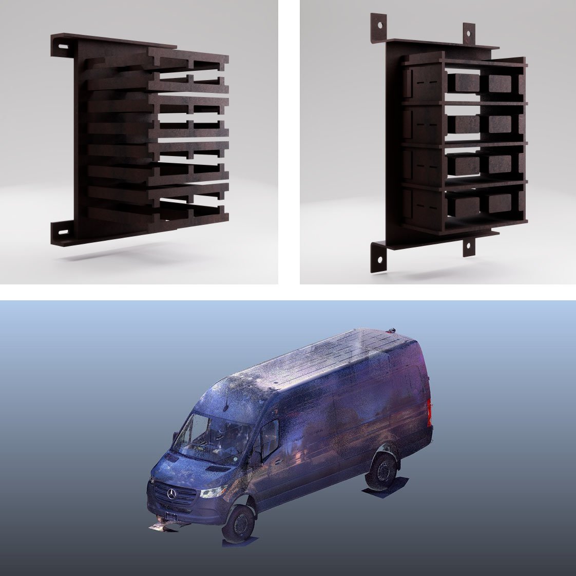
Our scanning and modeling capabilities also extend to object and vehicle-sized projects. Using high-density scanners, we capture small objects with fine detail and create models or export meshes for various use cases.

High-Resolution Mural Capture & Panel Integration
We provide end-to-end documentation and integration of large-scale artwork for architectural applications. Our team captures murals using high-resolution photography with controlled lighting to ensure accurate color, minimal distortion, and seamless image stitching. We process and calibrate imagery for print-ready deliverables, then coordinate directly with panel layouts to ensure precise alignment in the field. To support installation, we also capture panel locations with LiDAR, draft layouts in Revit, and export CAD drawings—delivering a fully coordinated, construction-ready solution.
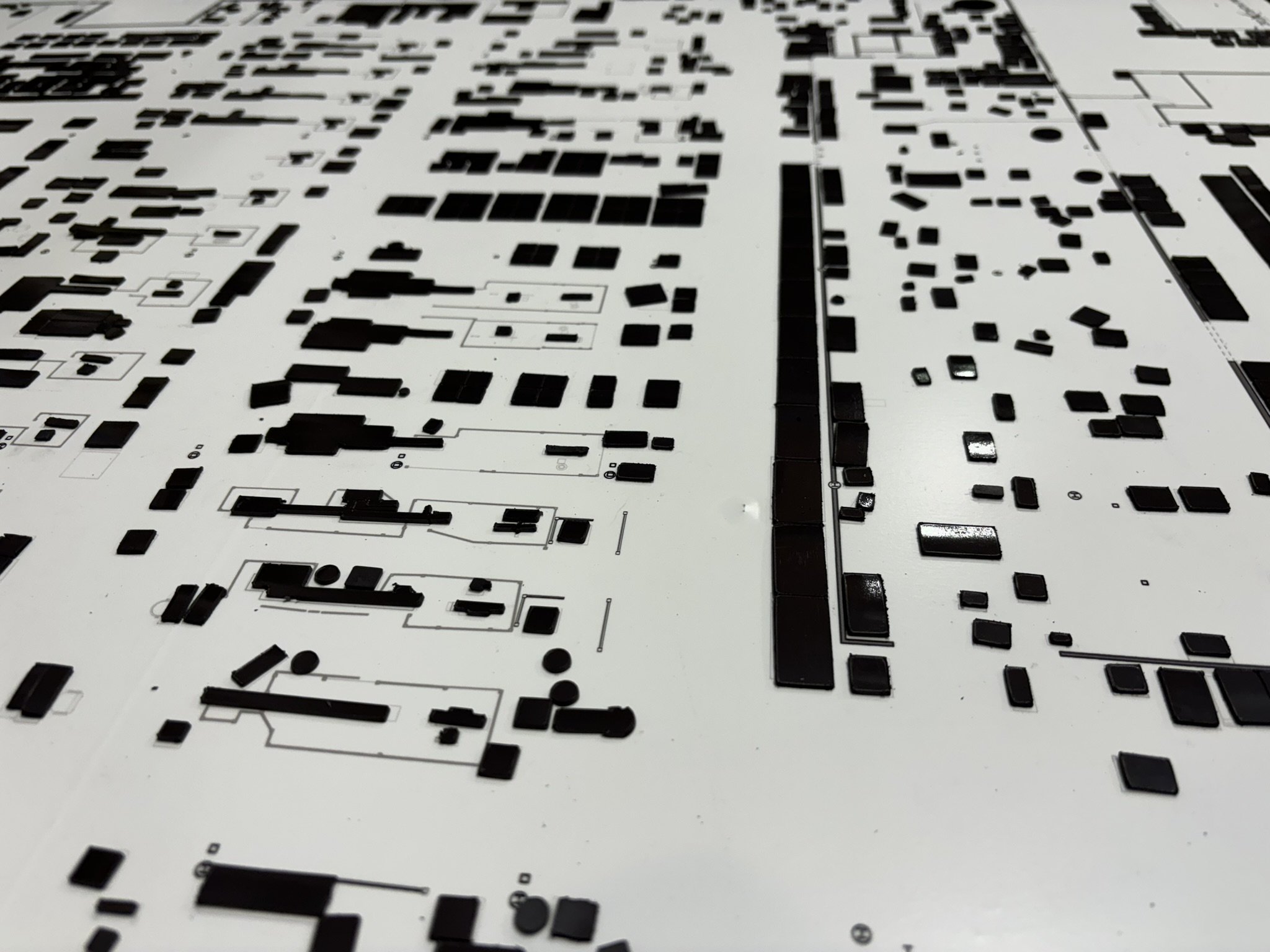
Magnet Board Equipment Plans
Following scanning and modeling of a space, we can print and cut magnets for all equipment pieces, for easy rearrangement and space planning.
More Services
In addition to our LiDAR services and applications, we often include additional services in our scope of work. Each of these add level of additional visual communication.
360 Tours
Our 360 virtual tours allow online visitors to walk through the interior and exterior of the environment. The tour will assist in communication between client, designer, and contractor. For real estate, the tour will help interested buyers. We have also made 360 tours for education. See example 360 tour.
Floor Level Mapping
We create floor level analysis diagrams with tolerances less than 1/10”. These diagrams are color-coded and scaled. Measure using our easy to use grid to locate low lying areas. Identifying and fixing problem areas couldn’t be easier! See example.
Drone Videography and Photography
Drone aerial video captures beautiful angles of your project, demonstrates the proximity to nearby attractions, and communicates the feel of the place. We edit and arrange the video to upbeat music. Add these to an MLS listing. See example.
Construction Analysis
Using survey-grade LiDAR, 3D Data Pro performs precision altimetry to compare as-built conditions to construction plans. Our services include building settlement analysis, slope evaluation, and graphical comparison to design intent. These cases are protected under NDA.
3D Data Pro Recent Projects
[ Project Name, Project Type, Location, Area (SF), Scope of Work, Systems Documented ]
1 University of Wyoming School of Engineering As-built documentation Laramie, Wyoming 250,000 LiDAR site survey, systems photo documentation, Revit as-built modeling Architectural, structural, mechanical
2 Tantra Lake Apartments As-built documentation and visualization Boulder, CO 145,000 LiDAR site survey, systems photo documentation, Revit as-built modeling, data geolocation, drone aerial orthophotography, 360 tour visualization Architectural, structural, mechanical, electrical
3 Overlook At Thornton As-built documentation and visualization Thornton, CO 180,000 LiDAR site survey, systems photo documentation, Revit as-built modeling, data geolocation, drone aerial orthophotography, 360 tour visualization Architectural, structural, mechanical, electrical
4 Governmental Research Building As-built documentation and visualization Boulder, CO 80,000 LiDAR site survey, systems photo documentation, Revit as-built modeling, 360 tour visualization Architectural, structural, mechanical, electrical
5 HEB Grocery Stores As-built documentation and visualization San Antonio, TX, College Station TX, Boerne, TX, Over 600,000 LiDAR site survey, systems photo documentation, data geolocation, drone aerial orthophotography, 360 tour visualization Architectural, structural, mechanical, electrical, feasibility and condition reports
6 Johnson Wales Campus Building As-built documentation and visualization Denver, CO 180,000 LiDAR site survey, systems photo documentation, 360 tour visualization Architectural, structural, mechanical, electrical
7 Paul Derda Recreation Center Building movement measurement and analysis Broomfield, CO 80,000 LiDAR time-stamped data collection, high precision altimeter data collection, photo documentation, drone aerial conditions documentation, 360 tour Architectural, structural
8 Elks Lodge #224 As-built documentation and visualization Aspen, CO 35,000 LiDAR site survey, systems photo documentation, 360 tour visualization, as-built Revit modeling and detailing Architectural, historic preservation details
9 Oil Work Over Rigs, Equipment, and Documentation of Incident and Accidents Forensic Engineering Texas, New Mexico, Colorado, Wyoming, Montana, Oklahoma Each site is approximately 2 acres LiDAR site and asset survey, evidence photography, drone orthophotography and oblique imagery, 360 tour visualization, graphics and animations for civil litigation Evidence documentation, land survey, structural and topographical modeling, accident scene diagrams, animations
10 Amazon Site Assessments Feasibility Studies for Prospective Amazon Go Stores USA Each site was approximately 6,000-10,000 LiDAR site survey, systems photo documentation, Revit as-built modeling, data geolocation, drone aerial orthophotography, 360 tour visualization Architectural, structural, mechanical, electrical, feasibility and condition reports
11 Vehicle incident and accident scenes Forensic Engineering USA Each site is approximately 1 acre Completed hundreds of site surveys using total stations, drone technologies, LiDAR technologies, topographical modeling, data geolocation. Followed by camera matching photogrammetry, 3D post processing, 3D modeling, graphics and animations for admission into civil and criminal litigation and arbitration Evidence documentation, land survey, building as-built documentation and visualization
12 Marshall Fire Forensic Engineering Boulder County, CO 200 acres (area of origin only) LiDAR site and asset survey, evidence photography, drone orthophotography and oblique imagery, 360 tour visualization of the site and witness vantage points. Evidence documentation, land survey, building as-built documentation and visualization
13 Boston Children’s Museum Scan to BIM including MEP 161,000 SF Revit drafting from client template including architecture, structure, MEP, and landscape. 2D drawings and walk-through tour included.
14 Colorado Springs Charter Academy Scan to BIM including airborne LiDAR mapping 80,000 SF Revit drafting from client template including architecture, structure, MEP, and landscape. 2D drawings and walk-through tour included.